
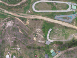
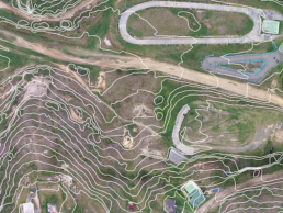
In Drone Pixel we integrate drones and virtual reality creating an information model in the cloud where you will have access to specialized data that will allow you to reduce costs, improve crop profitability and reduce environmental impact.
Evaluate the state of vegetation, grass, crops, plantations to make decisions from any platform.
Our intelligent data model allows you
![]()
Early detection of natural agricultural crop diseases and pests.
Managing human and financial resources processes.
Update your cadastral file.
Plan harvest according to you quality targets.

More surface coverage in less time

Drones are cheaper than helicopters and light aircraft

Periodic aerial inspections of critical points
We offer an efficient, effective, precise and complete response with our integration of images, videos and virtual tours.