In the Beginnings, UAV or Drone technology was used as equipment for aerial filming, in audiovisual, commercial productions, sporting events since they were seen simply as a flying camera with great, flexible features and in some cases replacing the costly work of helicopters.
However, it has now been shown that they are capable of developing many activities so far carried out by workers, reducing human risks by 90%, execution times and costs, for example, performing work at height, surveying, inspections, monitoring large extensions, sites inaccessible or at risk of collapse.
The most common situation in which drones are used is in risk prevention, freeing operators from tasks known in the Anglo-Saxon culture with the three-D Dirty, Dangerous and Dull, contributing to the acquisition of accurate data in real-time.
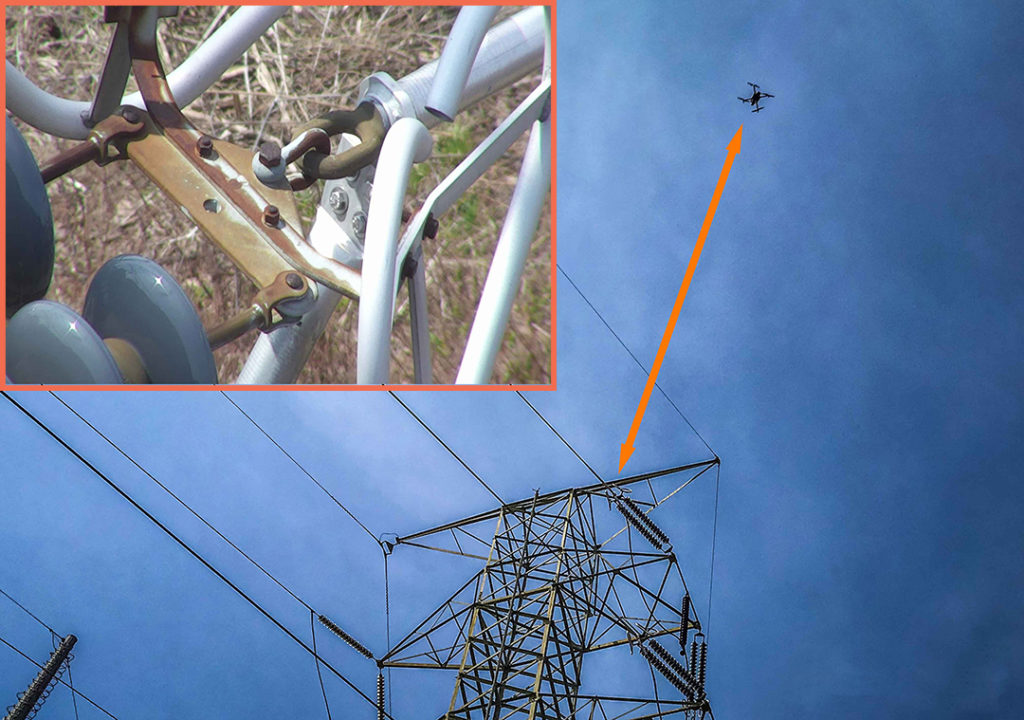
The usual use of platforms and scaffolding to perform inspection work on building facades, in the supervision of infrastructures with difficult access, tanks, pipelines, seaports, for example, in the structural elements of certain bridges (board, loading docks, pillars) , in high voltage electrical towers, telecommunications towers or in chimneys and elevated ducts in industrial enclosures, among others, constitutes an important risk that causes in some cases occupational accidents and exposes the human resource to high risk situations, providing little useful information incurring higher costs
Cost reduction is closely linked to saving time in the execution of high-risk tasks. This saving, depending on the type of project can reach up to 80%.
Use of drones in Power inspections
Specifically, power companies use drones or UAS
- As auxiliaries in the review of distribution lines and power transmission. In this way, they complement the work of the operators to solve defects that could not be found.
- To detect faults or anomalies in the elements of the lines, support structures, vegetation.
- To detect hot spots that may be associated with inadequate contact, generate heat maps of sub-stations, thus complementing the work of operators to solve defects that are not observed with the naked eye.
Thanks to the flexibility, interoperability of sensors, reduction of air risk, among others the use of drones has managed to expedite efficiently, reporting processes, risk management in natural catastrophes, new developments for environmental control and monitoring, since they can reach a height of up to 100 meters and, thanks to the zoom camera, collects all the necessary data from all kinds of angles and stores them visually.
This technology is the perfect ally for the platforms of GIS (Geographic Information System) because it allows adding layers of useful geographic information to develop resource planning strategies among others necessary in the country.
In short, the use of these unmanned aircraft has proposed a wide development of applications, from the electrical sector, Telecommunications, Construction, Oil and Gas to the future as a method of transport.
It is important to emphasize that the integration of human talent and training with this technology has to be done in a responsible and safe way, to avoid incidents, and guarantee the success of the acquisition of the data, transformed into useful information to make decisions.